

ABOUT
OAK RIDGES MORAINE
1900
Square Kilometers
1760
Different Species
66
Rivers and Streams that begin in the Moraine
1
Unique Habitat for us to Protect
How the Oak Ridges Moraine Was Formed
Our Moraine is 12,000 years old, 160 km long and covers over 470,000 acres, and is part of Ontario’s Greenbelt. At almost 2 million acres, ours is the world’s largest permanently protected greenbelt, stretching over 325 km from Rice Lake in the Oak Ridges Moraine to Tobermory to the Niagara River. It keeps our farmlands, forests and wetlands safe and sustainable, and provides fresh air, clean water and healthy local food.
Thanks to our partners and friends, you can also check out publicly accessible hiking trails!
Explore the Moraine by watching this video about its historical formation and what services it provides to us every single day!
Quick Facts about the Oak Ridges Moraine

-
The Moraine stretches 160 kilometers from just east of Mono Mills at the Niagara Escarpment to Castleton, north east of Cobourg
-
North and south the Moraine is ‘narrowest’ ( < ½ km ) at Bewedley on the west end of Rice Lake and (just about ½ km) at Simcoe Street north of Oshawa. An area of major concern for connectivity of the Moraine occurs within Richmond Hill at Yonge Street where the only undeveloped ‘natural linkage area’ is considerably less than ½ km in the area currently referred to as Corridor Park
-
The Moraine covers a geographic area of 1,900 square kilometers (734 sq mi) approximately 1/3 of the size of Prince Edward Island!
-
64 rivers or streams begin on the Moraine and run either south directly into Lake Ontario, or north to Lakes Scugog, Simcoe or Georgian Bay (Lake Huron). Some of these watercourses include The Credit, Humber, Don, Rouge, Ganaraska, Pigeon, Nonquon, Beaverton, Black, Holland (East and West) and Nottawasaga Rivers; Etobicoke, Duffins, Lynde, Oshawa, Bowmanville, Burnley and Innisfil Creeks
-
90% of the Moraine is in private ownership
-
60% of the Moraine is in the Greater Toronto Area, (Peel, York and Durham Regions) 20% in Northumberland County, 7% in the City of Kawartha Lakes, 5% in Simcoe County, 3% in Peterborough County and 1% in Dufferin County
-
32% of the Moraine is covered in upland forests and is one of six recognized areas for forest bird diversity in southern Ontario
-
5% of the Moraine is wetlands – mostly smaller but very important in their function as headwaters and also as isolated habitat for waterfowl
-
There are 37 kettle lakes and 46 bogs/fens (noteworthy for northern plants and animals)
-
0.2% of the Moraine is covered with 161 remnant tall grass prairie, sand barrens and oak-pine savannah/woodlands
The Moraine has an enormous amount of biodiversity.

There are:
-
1,171 plant species
-
125 species of moss
-
166 breeding bird species (and more through migratory seasons)
-
30 species of reptiles and amphibians
-
51 mammal species
-
73 fish species
-
74 species of butterflies
-
70 dragonflies and damselfly species
-
88 species are provincial or national species at risk and 466 are moraine rare (Canada as a whole has 71,500 species of plants and animals, with approximately 422 species at risk)
-
There are 72 life and earth science Areas of Natural and Scientific Interest (ANSI’s) covering 15% of the moraine and 82 Environmentally Significant Areas (ESAs) For more information on these, check out This Link
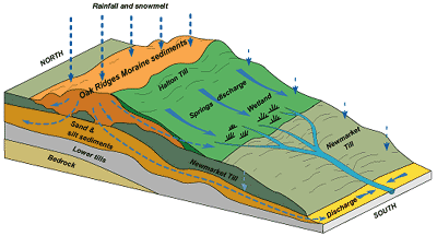
However, the Oak Ridges Moraine is more than just a beautiful landform feature with its breathtaking vistas, rolling hills, wooded valleys and ‘kettle’ lakes. Its most precious feature lies hidden below the grounds’ surface.
For more information, check out the Water and the Moraine Tab


Habitats of the Oak Ridges Moraine
From the towering old-growth forests of Happy Valley, to the globally threatened ecosystems of savannah and tall-grass prairie, the Oak Ridges Moraine boasts many amazing habitats. The Moraine is 30% forested, has 130 wetlands, many kettle lakes and centuries-old wood lots. All these green spaces create spectacular hiking and rejuvenating natural encounters for thousands of people, all year round.
However, what makes the Moraine even more unique is the green oasis it provides to wildlife in the most densely populated region in Canada. The continuous green corridor of the Moraine allows wildlife species and ecosystems to remain connected in a way that is vital to the health of each, and that makes the whole of the Moraine a very special place. What will you explore on our Moraine?

The landscape of the Oak Ridges Moraine is peppered with various bodies of water including many ponds, lakes and wetlands. Kettle lakes, peculiar to the glacially-impacted landscape, form when huge blocks of ice remain, half buried in sand and gravel, after a glacier’s retreat. When the ice block melts, a hollow is left that eventually fills with ground water, becoming a kettle lake or wetland.
Sometimes lakes develop into bogs—unique vegetation communities dominated by sphagnum moss. The moss grows into the lake from the edge and forms a floating mat of vegetation. Trees such as Tamarack and shrubs like Labrador tea colonize these mats over time. A mature bog ecosystem can cover an entire lake, often sheltering rare and ecologically unique species that are adapted to the acidic conditions of the bog.


